Wolverton's Atlas of Monmouth County, New Jersey (1889), included two maps of particular interest to Aberdeen-Matawan residents.
Matavan (Plate 35)
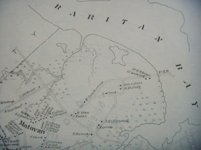
 |
| Detail of Matavan, NJ (Wolverton's Atlas of Monmouth Co, 1889, Plate 35) |
This map covers the entire area of what is now Aberdeen-Matawan, from the Raritan Bay in the north to Marlboro in the south, and from the Middlesex County line in the west and Keyport, Raritan (Hazlet), and Holmdel in the east.
- Towns: Matavan, Matawan, and Mount Pleasant
- Post Offices: Cliffwood and Matawan
- School Districts: Cliffwood No 45 (northwest), Mount Pleasant No 46 (southwest), Point No 47 (Matawan), Lower Point No 48 (northeast), and Oak Grove No 58 (southeast).
- Two major railroads: the New York and Long
Branch Railroad runs from northwest to southeast, and the Freehold and
New York Railway from northeast to southwest.
- Two railroad stations: Cliffwood and Matawan
- Water resources (not labeled): Treasure Lake, Whale Creek, Long Neck Creek, Matawan Creek, and Gravelly Brook.
 |
| Matavan. (Wolverton's, 1889) Detail shows two routes leading into Cliffwood Beach. |
The map shows two unlabeled routes into what is now Cliffwood Beach. One route looks to be Cliffwood Avenue, which seems to turn at South Concourse and heads to the shore, where a pier is situated. The second route looks to be Prospect Avenue, which today is interrupted by State Route 35. The map shows Prospect going south, but today it makes a sharp right and leads toward Matawan Aberdeen Middle School (MAMS).
 |
| Matavan (Wolverton's Atlas, 1889). Detail shows Prospect Avenue as dirt road leading to brickyards along Matawan Creek. |
In 1889, Prospect Avenue appears to have become a dirt road at some point as it reached a series of
brickyards along the western shore of Matawan Creek. Keep in mind that
the brickyards are situated approximately where the Garden State Parkway
(GSP) was built in the mid-20th century. Matawan Creek currently passes under the GSP and the railroad tracks.
 |
| Matavan (Wolverton's Atlas, 1889). Detail shows brickyards and steamboat dock along Matawan Creek. |
This detail (above) shows the J Manning Brickyard, H H Longstreet Brickyard, D & C Close Brickyard, and the W Maggs Brickyard along Matawan Creek in 1889. The steamboat dock, where one of the famous shark attacks took place in 1916, is across the creek.
Speaking of the shark attacks, you might have wondered if the Stillwell on the map (above, lower left) was related to Lester Stillwell, one of the victims of the attacks. Lester's father was William Stillwell, but he lived in Manalapan until after 1910. The 1870 Federal Census listed a Henry C Stillwell, age 29, with wife Cordelia and daughter Sarah, living in Matawan. Henry had a farm worth $30,000 and $5,000 in personal property. Perhaps Henry is the H Stillwell on the map. He and his family were living in Holmdel in the 1880 Federal Census, along with what appears to have been his parents, John S and Fannie A Stillwell. They could have held onto the farm in Matawan or moved back in time for the atlas. Unfortunately, the 1890 Federal Census is unavailable due to a fire. The 1900 Federal Census is no help; Henry was a fish dealer living with Cordelia in Jersey City.
Matawan (Plate 28)
 |
| Matawan. (Wolverton's Atlas of Monmouth Co, 1889) |
 |
| Matawan (Wolverton's Atlas, 1889) Detail of Main St and Atlantic at the railroad. |
 |
| Matawan (Wolverton's Atlas, 1889) Detail of Main St and Washington St, where Aberdeen Creek passes under the road. The Baptist and Presbyterian churches and the Presbyterian parsonage can be seen on Main St (far right). Middlesex St (far left) is where Route 34 would be now. |
 |
| Matawan (Wolverton's Atlas, 1889). Detail of Main St and Broad St between Church St and Clinton St. |
 |
| Matawan (Wolverton's Atlas, 1889). Detail shows train station as "passenger depot" (left); the railroad trestle over Matawan Creek is just west of Main St. (right); a dirt road followed the creek to join James Lamberson's lime kilns and the coal yard (top) with the dock and train tracks. |
 |
| Matawan (Wolverton's Atlas, 1889). Detail of the train station (passenger depot and freight depot); a canning factory and the Village Hotel can be seen. |
 |
| Matawan (Wolverton's Atlas, 1889). Detail. |
Above are detailed views of Wolverton's 1889 map of what is now downtown Matawan. It shows the Borough 40 years before the two lakes (Matawan and Lefferts) were established. Main Street and Atlantic Avenue were the spine of this image, while Matawan Creek and Gravelly Run formed the borders. The Holmdel Turnpike and Middlesex Street would later become State Route 34.
When you look at the map, note just how short Johnson Avenue was and how Broad Street ended at Little Street. And look at Aberdeen Creek, which still crosses under Main Street into what is now Terhune Park at Washington Street at one end and drains into Lake Lefferts at the other end.


0 comments:
Post a Comment