A blog about living in Aberdeen, New Jersey.

Showing posts with label development. Show all posts

Friday, August 21, 2015

History: State Route 35 South at GSP Exit 117 in October 1956


My wife came across this interesting video from the Jack Kirby Archives showing a driver exiting the Garden State Parkway at Exit 117 on 6 October 1956. He headed south on Route 35, turned right on Bethany Road, then made a left into a new housing development under construction in Holmdel.

I've made a timeline of this short video and added some stills from the video. Although I've been careful, I'm sure I've omitted some observations and made some mistakes. I'd be interested in your additions and corrections.
  • 0:10 Garden State Parkway Exit 117; Sign: Matawan/Keyport
  • 0:22 Sign: Keyport/Keansburg (left arrow); Middletown (right arrow); Keyport water tower in distance
  • 0:26 Merged onto Route 35 South - view in distance of Route 35 North overpass
0:29 Sign; Route 35 N visible in background

  • 0:29 Sign: Red Bank/Asbury Park (right arrow); Keansburg/Atlantic Highlands (left arrow)
  • 0:31 Signs: Route 35 (right arrow); Route 36 (left arrow); tall, narrow sign across the highway, illegible
  • 0:33 Beers Street intersection on right?
0:36 Turn in road before current Home Depot

  • 0:35 Turn in roadway approaching entrance to current Home Depot; Sign: Briarcliff Homes 
  • 0:37 Sign: Route 35 Red Bank/Eatontown/Asbury Park
  • 0:38 Sign: Old Manor Estates
0:38 View of Route 35 S heading towards Holmdel Road

  • 0:40 Sign: Split Rock Estates, Turn Right; downslope heading towards Holmdel Road
0:44 Dutch Motel; unidentified restaurant

  • 0:44 Signs: Esso (right); Dutch Motel (right); restaurant (right); Texaco (left)
  • 0:45 At Holmdel Road & Route 35
0:46 Old Manor Estates sign; Sunoco garage

  • 0:46 Sign: Old Manor Estates, Turn Here, from $14,990
  • 0:48 Sunoco garage
0:52 Restaurant with airplane on roof; steaks and chops

  • 0:52 Restaurant with airplane on roof near roadway; sells steaks and chops; possibly nearing Hazlet Avenue intersection

  • 0:58 Signs: Foxwood Homes (right); Molly Pitcher Inn (left, in distance)
  • 1:00 Sign: Turn right at Bethany Road
1:03 Fitzgerald's Green Acres Bar

  • 1:03 Fitzgerald's Green Acres Bar
  • 1:07 Sign: Raritan Ridge, left turn
  • 1:08 Sign: Old Manor Estates, Holmdel Township, 200 Feet Turn Right

1:11 Farm stand and truck

  • 1:11 Farm stand, possibly Casola Farms; old truck has an illegible business identified on side
  • 1:14 Bethany Road
1:19 Bethany Road railroad crossing, looking southwest

  • 1:19 Bethany Road railroad crossing
  • 1:25 Bethany Road at intersection with Telegraph Hill Road (on left)
  • 1:31 Old Manor Estates model homes on left and right side of Bethany Road; parking area  on right
1:39 Bethany Road approaching construction site

  • 1:39 Bethany Road - approaching Old Manor Estates construction site
  • 1:46 Bethany Road - major construction site
  • 1:56 Bethany Road - Newly built Old Manor Estates homes
Notes:

FITZGERALD'S GREEN ACRES BAR

The 18 Mar 1981 edition of The Bayshore Independent contains the obituary of Frank G Havey, of Hazlet, who moved to the area in 1958 and worked as manager at Fitzgerald's Green Acres Bar for eight years.

SGT PEPPER'S CLUB

The restaurant with the airplane on the roof was originally called Hazlet Lunch and was operated by Bill Kahlert, according to Hazlet Township, pp 12-13, by William B Longo. Kahlert was a pilot and owned his own plane. A plane was added to the roof at one point and the restaurant became a local landmar,, according to Longo, who said the luncheonette closed in the early 1970s and reopened as a disco later that decade. (Check out Longo's old photos, post cards)

A Keyport Facebook group consensus was that Hazlet Lunch later became known as Sergeant Pepper's and then The Red Barron, burning to the ground sometime in the late 1970s or early 1980s. The group said it was located where the Midas service center is situated today, near the Hazlet Fairgrounds and the Buhler automobile dealership.

The 29 Aug 1979 edition of the Bayshore Independent (pg 2)  reported on the 24 Aug 1979 fire that destroyed Sgt Pepper's Club on the eve of its reopening. Heat lamps being used to dry a new coat of polyurethane on the bar caused the fire, according to officials. The roof caved in and the airplane fell inside the burning structure. The club, which operated for two years as Sgt Pepper's, operated as a go-go bar during the day and a rock-n-roll club at night. It had been closed for two months due to ABC violations related to the go-go bar. It had previously been called The Hangar, The Red Baron, and The Hazlet Lunch. The owner planned to rebuild.


25 Mar 2016 Note: Timeline of video has been edited above based on feedback in comments below.

Wednesday, August 5, 2015

A&P in Cliffwood to Close Before Labor Day

The A&P grocery store in Cliffwood is closing its doors on Friday 4 September 2015. It is part of a larger corporate bankruptcy, according to the 20 Jul 2015 edition of The Wall Street Journal. Other local A&P groceries being closed include the Route 9 store in Old Bridge and the store on Route 35 in Holmdel. Corporate is raising some quick cash as part of its Chapter 11 proceedings. Others not yet named will also close or change hands soon enough.

The Atlantic and Pacific Tea Company opened this grocery store in Cliffwood on 6 October 1959. (See related article)

The Cliffwood store survived the arrival of Price Club, whose  box store in Hazlet soon killed the small, family-run Foodtown in downtown Matawan. But A&P couldn't stop the bleeding as shoppers flocked to the many well-stocked and competitively priced stores in the area, including Shop Rites on Lloyd Road in Aberdeen and Route 35 in Hazlet and Stop n Shops in Aberdeen and Keyport.

Opinions of A&P in Cliffwood weren't mixed; the store had grown increasingly unpopular in the area, leaving it to serve more as a large convenience store than as a grocer. It was my impression that A&P wasn't as "fresh obsessed" as its advertising implied. I can't tell you how many times I found expired products on the shelf or in my grocery bag. My neighbors complained that prices weren't competitive and selection was poor.


Residents will just have to wait and see what will become of the space. The economy is strong and vacancies that abounded along Route 35 two or three years ago have all been filled. The intersection of Route 35 and Cliffwood Avenue has just been upgraded. Perhaps a new tenant will be found quickly?

Saturday, December 20, 2014

History: Green Acres Project Planned for Cliffwood Beach (1976)

The 29 Sep 1976 edition of The Matawan Journal (pg 2) contains the following article that both laments the lost glory of Cliffwood Beach as a popular beach resort and boasts of plans for a Green Acres project to make a park with tennis and basketball courts and other amenities just off the beach.

I moved to Cliffwood Beach two years after this article was published. The park project was all that was described in the article and more, with basketball courts, fenced-in tennis courts, bocci ball frames, swings, slides and climbing toys  for children, and a small recreation building for a recreation manager to provide equipment by the hour. There was a new sloping lawn, parking lot and paved pathways intersecting the property. Bird watching signs were placed along a paved shore path near Treasure Lake to encourage nature enthusiasts.

The beach area was rather isolated, though, so it became a place for people to hang out after hours. While much of the activity was innocent, being mostly out of sight led to graffiti, destruction of equipment and property, other crimes, and frequent visits from the police. The bird watching signs were defaced and torn off their posts. Eventually the recreation building had to be torn down, the tennis courts were converted into a street hockey court and then abandoned, and new swings and recreational equipment and a beach volleyball area were added. The seawall -- already in existence by 1976 -- was made into a promenade a few years ago, with formal access from the harbor end of Cliffwood Beach.

Sandy flooded the area, bringing with it a heavy coating of the dune sands pushed off the beach and onto the basketball courts. The ground in the park became spongy and alkali. The paved walks were submerged in muck and mostly unseen. The storm also changed the effect of the tides on the park -- tidal flooding began to fill the roadway and low lying parkland with frequent surges of seawater and even actual waves. The seawall promenade and the land behind it were pounded and some sections undercut, lifted and cracked by the raging Raritan Bay, but the walkway mostly survived.

The article below starts out with local residents' reminiscences and local impressions of life in Cliffwood Beach. They offer their personal theories of how the resort, built in the 1920s, had been left untended and for the most part disappeared fifty years later. The article ends with local officials discussing the planned creation of an adjoining park that rose and has mostly fallen during the ensuring 40 years.

Can Cliffwood Beach Recapture Glory of Past?

MATAWAN TOWNSHIP

You wouldn’t know to look at it, but Cliffwood Beach was once one of the garden spots of the Jersey shore.

Now all that remains of the boardwalk is a line of forlorn black pilings poking their heads above the waves. The dance hall has vanished without a trace. And the salt water swimming pool resembles a giant concrete planter for reeds and brush mysteriously deposited in the high ground above the shoreline.

The swimming beach has been eroded away and most of the fossil-rich cliffs have fol­lowed them , blasted by storm-driven waves on one side and undermined by septic tank seepage on another.

Treasure Lake is still there, but the water is shallow, stag­nant, and slick with algae.

Some Cliffwood Beach resi­dents remember the glory days, before harsh weather and public and private neglect took their toll. Mrs. Mardell “Mardy” Edwards, Woodmere Drive, rummaged through her keepsakes to dig out a sheaf of old Cliffwood Beach postcards.

“ I ’m not really an old-tim­er," Mrs. Edwards said. “I’ve only been here 27 years. But it was beautiful, really some­thing. Now you can see what neglect can do.”

The postcards might have come from another world. Still fresh with the pastel colors of 40 years ago, they depict clean beaches, wide boardwalks, a bustling pool scene, rowboats on a tree-shaded lake, and an elegant dance hall.

“People who drive by this area on the highway have no idea of the resources that are available,” Mrs. Edwards said. “ The beaches around here, years ago, were poor man’s paradises.”

A neighbor, Mrs. Alex Mose, was a regular summer visitor to Cliffwood Beach before moving here 16 years ago.

“We had homes up on the cliffs, and you could see all the way to New York ,” she re­called . 

“There was dancing in the casino, bungalows every­ here. But the people at the helm were asleep at their posts, and they let the beach go to pot. You can’t imagine what we had here at one time.”

“They didn’t think too much of maintaining the area for the future as they did of develop­ing it for the present,” Mrs. Edwards said. “There was al­ways a lack of maintenance and then we had a big building boom in the 1950s.” 

The building boom, she con­tinued, brought unexpected problems. “We have clay soil around here, and most of the houses built then had septic tanks,” she said. “ Clay soil doesn’t go with septic tanks. The tanks seeped and the cliffs were washed out from under­neath.”

Over the years, Mrs. Edwards said, hurricanes caused damage to the area that was never repaired.

“The salt water pool was bulldozed over after storms cracked it ,” she said, “ and the waves carried most of the beaches out to sea. A lot of the bungalows were washed away and so was most of Cliff­wood Drive .”

Nature, however, has not been the only destroyer.

“The new sea wall is already decorated with brok­en beer bottles,” Mrs. Edwards said. “Nobody goes swimming barefoot anymore. We keep a garbage can down there by the water’s edge, but people throw the bottles any­way.

“Then there’s the eternal battle to try to save the horse­shoe crabs,” she went on. “Some people think they’re doing us a favor by killing them, and we tell them, ‘Next time bring the crabs home and let ’em decay under your windows, and you’ll see how much of a favor it is.’"

Some people believe—and they’re wrong—that you can get stung by the crab’s tail, but  nobody’s ever hurt. By broken glass, yes; but by the horseshoe crabs, no.”

Although the story of ne­glect in Cliffwood Beach is a sad one, Township Manager Donald Guiuzzy said Matawan is hopeful of doing much to restore the area.

A sea wall has already been built to protect the land against the waves, and an earthen slope has been raised behind the wall.

“We hope to finish our slope protection project by mid-Oc­tober,” Guiuzzy said. “We’re planting grass, some flowers, and crown vetch to stop ero­sion.”
 
The next phase of the overall project, he said, will be to install recreation facili­ties, including four tennis courts, shuffleboard and bas­ketball courts, chess and checkers tables, perhaps bocci and horseshoe pits, a parking area, walkways, and “tot lots” for small children. Guiuzzy said the phase should be finished by spring.

“The recreation phase is all funded by state and federal grants,” he said. “We went out and aggressively tried for grants, and we got them.”
 
Guiuzzy said projects for restoration of the beach itself “look good for approval” by the Army Corps of Engineers.

“We want to restore one mile of bathing beach,” he explained, “and we hope we can start doing it in the winter. So far, we’re four years ahead of schedule. We’ve shown some of our plans to the engineers and gotten some very favorable reactions. We think they’ll help us.” 
 
Half of the cost of restoring the beach, Guiuzzy said, would at first be funded by the federal government and half by the township. Ultimately, he said, the township hopes to secure 10 percent of the cost from the county and 25 percent from the state. 

“There’s a lot of potential," Guiuzzy said. “ For instance, we’d like to cooperate with Old Bridge Township to create a marina on Whale Creek, right on the county line , financed by the Corps of Engineers. I think that would be a great joint project for the two townships.”

Guiuzzy said he didn’t know if the area could be restored to all its former splendor as a resort site.

“It’s difficult to make a prediction like that,” he said, “But one thing I do know: we’re making it a lot better than it is now."

Sunday, August 10, 2014

Aberdeen Transit Village Lot Cleared

The future Transit Village lot at Harrison Avenue and Atlantic Avenue, next to the Aberdeen-Matawan train station, is finally cleared. Over the last few months the construction crews have come in and leveled the old factory, sorted and chopped up the debris and hauled it away. Above is a shot of what the lot looked like a few months ago before the demolition, courtesy of Google Street View.


And this is what it looks like now.  

Below is some video of the final demo work.


Nice to see this long awaited project getting off the dime at last.

Sunday, July 13, 2014

Up The Creek Under Construction, Keyport


They've made considerable progress this weekend on the new Up the Creek in Keyport.

Saturday, July 12, 2014

Union Beach Borough Strategic Recovery Planning Report

Union Beach Borough approved and published its Strategic Recovery Planning Report on 17 April 2014. It is a very detailed summary of what happened to Union Beach in Superstorm Sandy, what has been done so far and what still needs to be done to get the place back on its feet. We all need to support our neighbors in Union Beach as best we can.

Tuesday, July 8, 2014

Up The Creek Tavern Being Rebuilt in Keyport

The Up the Creek Tavern, a favorite among boaters at Keyport Marina, was severely damaged in Superstorm Sandy and had to be demolished. Good news is that the tavern is being rebuilt. If you drive by along Amboy Avenue from Cliffwood Beach or cross the bridge on West Front Street from Keyport, you will see a set of tall, cinderblock posts sticking up like soldiers in a vacant lot next to the marina. The building will sit high above the tide. (Let's hope the parking lot gets a bit of a lift as well.)


The 28 May 1970 edition of The Matawan Journal contained a photograph of the grand opening of Up The Creek Tavern on Friday 22 May 1970.

UP THE CREEK OPENS - Matawan Creek, that is. The grand opening of the new inn took place Friday at 5 pm at the West Front St, Keyport establishment. Shown at the ribbon cutting ceremonies are, from left, Pete Peterson, Mayor Robert Strang, Walt Steager, and Jim Dickerson. The three co-owners, and the mayor, were on hand to greet some of the hundreds of the well wishers during the grand opening. 

The 30 Jul 1970 edition of The Matawan Journal carried the above advertisement for Up The Creek Tavern and Marina on West Front Street at the bridge in Keyport. The ad listed Jim Dickerson, Pete Peterson, Walt Steager and Harry Ross (Manager).

The 20 Dec 2011 edition of The Matawan-Aberdeen Patch included an obituary for James M Groome, owner and barkeep at Up The Creek restaurant in Keyport.

The Keyport Marine Basin has a news page that says "an all new Up The Creek Tavern is in the works. It will be higher and dryer." The marina has kept the tavern's Without a Paddle Grill and Catering menu on their site.

Saturday, July 5, 2014

History: Cliffwood Beach Club Adds 200 Bungalows at Treasure Lake (1926)

The 19 Mar 1926 edition of The Matawan Journal included this front page article about the addition of 200 small bungalows near Treasure Lake for Cliffwood Beach Club owners to use. The developer -- Morrisey & Walker -- borrowed this trendy vacation idea from the West Coast. These small "bungalets," which were built only 100 feet from the bay, were all destroyed in Hurricane Donna in 1960.

NEW INNOVATION AT CLIFFWOOD BEACH


"DIVIDED HOTEL” IDEA OF THE WEST COAST INTRODUCED.

One Hundred Fifty One-Room Bungalets and Fifty Two-Room Structures Completed This Week.


Work will be completed this week on a unique bungalow's colony being constructed for thc Cliffwood Beach Club near Treasure Lake, Cllffwood Beach. The development consists of  150 one-room bungalets and 50 two-room structures adapted from the "divided hotel” plan in successful operation on the Catalina Islands and other Pacific Coast resorts.

Charles W. Morrisey, president of Morrisey & Walkcr, Inc., developers of Cliffwood Beach, and an organizer of the Cliffwood Beach Club, in announcing the approaching completion of the building operations, declared that the demand for large houses has shown a steady diminution during the last few years along the shore.

The Cliffwood Beach Club, he continued, has endeavored to keep abreast of the vacation trend by the erection of "bungalets," as they are known on the coast, which will be managed on the lines of a hotel from a central administration building.

Occupancy of the bungalets will be limited to members of the club, which will have a maximum roster of 200 families, who will be required to furnish adequate business and social references. Registrations for the single rooms wlll be limited to four and for the two-room structures to six persons.

The houses are of frame 10x20 feet, and are located 100 feet from the shore. Particular attention has been paid to sanitary provisions and there will be daily garbage collections.Water and electricity for lighting and cooking will be provided. Each bungalet is sufficiently distant from its neighbor to insure a maximum of privacy.

Members of the Club, in addition to occupylng rooms in the "divided hotel," will also have access to playgrounds, tennis courts, boating facilities on Treasure Lake, a private beach and band concerts.

If the Innovation proves as successful in the East as it has on the Pacific Coast, Mr. Morrisey said it is probable it will be extended to other parts of the north Jersey shore.

Morrisey & Walker, Inc, the developers of this bungalow colony, is the largest seashore realty organization in New Jersey. The firm has successful developments at Cliffwood Beach, Shark River Hills, Asbury Park, West End, Belmar, Keansburg and Laurence Harbor. This firm has offices at 951 Broad Street, Newark, N. J„ three offices in Asbury Park, one on Cookman Avenue and two on the boardwalk, the famous Pirate ship at Cliffwood Beach known all over thc country, and at Keansburg and Laurence Harbor.

Monday, June 23, 2014

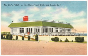
History: Cat 'n Fiddle, Cliffwood Beach (1927 - 1969)

The Cat 'n Fiddle Restaurant opened on a boardwalk on the Raritan Bay not long after the Cliffwood Beach community was first developed. It provided food, drink and entertainment by the shore for over thirty years. It was destroyed by a hurricane and was never rebuilt. Below are a selection of articles from The Matawan Journal marking its history.

The 1 Jul 1927 edition of The Matawan Journal had two small advertisements for the Cat 'n Fiddle placed throughout the paper, seven in all.  One recommended "When dancing at the Cliffwood Beach Casino, dine at the new seafood restaurant and cafeteria 'The Cat 'n Fiddle,' on the boardwalk. Reasonable prices." Another announced the new place and recommended the shore dinner at $1.50. It also named the music group playing on Sunday evening 3 July as the "famous Marimba Band from Central America, now the talk of New York."

The 28 Jun 1935 edition of The Matawan Journal (pg 1 col 4) included a small ad referring to the Cat 'n Fiddle as "Jersey's smartest rendezvous." The ad invited customers to "dine and dance on the water's edge. Perfect dinners 55 cents. Cocktails 25 cents, served on Cocktail Porch overlooking the sea. Dancing Friday, Saturday and Sunday. The Owens Brothers Orchestra from 7 pm to 1 am." An ad on page 9 announced, "Richard Jennings, manager of the Cat 'n Fiddle, will again supervise the service. Several bridge luncheons have been scheduled for this week. Each Friday, Saturday and Sunday evening a dance orchestra appears."

The 29 Jun 1944 edition of The Matawan Journal (pg 1, col 8) included a small advertisement for the Cat 'n Fiddle, which would reopen under new management on 30 Jun 1944. "Choice liquors and food at reasonable prices. No cover. No minimum. No tax."

The 14 Jun 1951 edition of The Matawan Journal contained a public notice by the following persons, as representatives of the Krieg Corporation, doing business as the Cat 'n Fiddle, who were seeking a liquor license in Matawan Township: William E Webster, Jr, President, 1250 Shore Concourse, Cliffwood Beach, NJ; R Edgerton Webster, Vice President, Jamesburg, NJ; Isabel F Webster, Secretary-Treasurer, 1250 Shore Concourse, Cliffwood Beach, NJ; and Cliffwood Beach Amusements, Inc, Cliffwood Beach, NJ.


The 26 May 1955 edition of The Matawan Journal (pg 1 col 5) ran an article announcing the opening of The Cat 'n Fiddle for the summer season. "Ray and his Jazz Bandits will be featured this summer at The Cat 'n Fiddle, in Cliffwood Beach, which will open this coming Saturday. Frank Cerranty will be at the bar and also will be manager of the establishment. The Cat 'n Fiddle is located on the Raritan Bay beachfront and it has been in operation for 25 years. It is owned by Morrisey and Walker, and is one mile from the Pirate Ship. There is a large parking area and reasonable prices will prevail for snacks and refreshments." The large ad above appeared on page 13.

The 15 Sep 1960 edition of The Matawan Journal (pg 1 col 3) provided the following excerpted reporting on damage caused by Hurricane Donna at Cliffwood Beach on Monday 12 September.

"Bayfront areas of Matawan Township took a battering from Hurricane Donna, especially in sections bordering Matawan Creek and in portions of Cliffwood Beach. During the worst of the hurricane, water was nine to 10 feet deep in the streets of Cliffwood Bench, police reported.

Damage in the beach area was estimated at more than $150,000. Ten families were evacuated from the waterfront area to the Cliffwood Fire House. Flooding in Cliffwood Beach reached all the way back to Greenwood Ave.

The storm lashed bay waters completely covered the roofs of the 180 unit colony of seacots* facing the bay at Cliffwood Beach and crashed through the rear of the Cat 'n Fiddle Restaurant, splitting the building in two. Police were stationed at the restaurant after looting was reported."

* The Seacot Village in Cliffwood Beach in Matawan Township

A seacot was a small summer rental, presumably an abbreviation for "seaside cottage." Helen Henderson shows a photograph of a "cozy seacot" and provides some information on rental prices, etc, on page 87 of her book "Around Matawan and Aberdeen."

An article in the 12 Aug 1948 edition of The Matawan Journal (pg 5) mentions the death of a renter by heart attack at the Cliffwood Beach Seacot Colony.

The 6 May 1965 edition of The Matawan Journal (pg 1) published the rates for seacots to hook up to the Cliffwood water supply for the season. Units with one water tap paid $8.80/season; it was $17.50 for units with three taps; and renters paid $7.30 for an outside shower.

-------------------------------------------

The Cat 'n Fiddle was destroyed by fire in December 1963, according to an article in the 16 Dec 1963 edition of The Red Bank Register.


The 2 Jul 1964 edition of The Matawan Journal reported the opening of the Cat 'n Fiddle for the season on 2 Jul 1964. The restaurant was apparently rebuilt after the December 1963 fire.

The 27 Jan 1966 edition of The Matawan Journal, which reported on a Nor'easter that struck the area on Sunday 23 Jan 1966, mentioned the Cat 'n Fiddle and seacots in a photo caption on the front page. The captionn read, in part:

"Driven by gale force northeasterly winds Sunday, waters of Raritan Bay overflowed the banks of Matawan Creek, flooding marinas and fishing stations along the way. The Cliffwood Beach section of Matawan Township was hard hit as water swept by the Seacot Colony, Cat 'N Fiddle Restaurant, and the Cliffwood Beach Pool. One woman, wife of the caretaker at the pool, had to be rescued by first aid men equipped with a boat. . . ."

The 10 Aug 1967 edition and 24 Aug 1967 edition of The Matawan Journal (pp 2 and 10, resp) contained an advertisement for the Cat 'n Fiddle, which was under new management. Hours were daily noon to 1 am; Saturday 10 am to 1 am. The Harry Thomas Review, featuring Eileen Walsh, was appearing on Fridays and Saturdays.

The 4 Jul 1968 edition of The Matawan Journal (pg 12) contained an ad for the Cat 'n Fiddle, which was promoting dancing and entertainment on weekends. Pat and Joe were the hosts.

The 31 Oct 1968 edition of The Matawan Journal (pg 16) reports on an investigation of fraud against the owners of the Cat 'n Fiddle.

ABC Sets Hearing For Area Tavern

A hearing will be held Nov. 4 in Newark offices of the Division of Alcoholic Beverage Control into charges against the Kreig Corp., owners of the Cat 'N Fiddle in Cliffwood Beach, of giving false information on a liquor license application.

The ABC alleges the stock of the corporation is held by three New York state residents. Corporate
officers insist the stock is in the hands of New Jersey residents as stated on its June 5, 1968 license application.

The 23 Jan 1969 edition of The Matawan Journal (pg 1) announced the state's revocation of the Kreig Corp's liquor license to operate the Cat 'n Fiddle due to the fraud charges.

 Details of the demolition of the bar and seacot colony have yet to be found.
UPDATED to add an image of the Dec 1963 Red Bank Register article, some details about seacots, details from the Jan 1966 Nor'easter article, news of new ownership in Aug 1967, and word of fraud charges in Oct 1968 that led to the revocation of the liquor license in Jan 1969.

Friday, June 20, 2014

Texas Roadhouse Steak Restaurant Coming to Holmdel in October 2014

UPDATE: Texas Roadhouse Steak Restaurant comes to Holmdel in October 2014, according to the chain's New Locations web page as of August 2014. It will be located next to Chili's, in the place where Macaroni Grill used to be.

Below is my original article, researching what would be built.

-----------------------------

The old Romano's Macaroni Grill building at 2105 Route 35 in Holmdel has been torn down, leaving Chili's standing alone with a large fenced construction area next door.

You may recall that Macaroni Grill closed a while ago and a hibachi place was supposed to open in the space. There were unexplained delays, signs in the window, and then Superstorm Sandy put a serious dent in the empty restaurant's infrastructure and that was that. No hibachi place ever materialized.

The new construction has been marked out on the ground and something is apparently to be erected in the next couple of months. The Holmdel-Hazlet Patch published a 2 December 2013 article saying that a Texas Roadhouse steak restaurant would be opening in this spot in July 2014. (Texas Roadhouse has a new locations web page, and I didn't see a listing for a new Holmdel location as pending.)

Holmdel Mayor Patrick Impreveduto bragged in a 16 January 2014 article in The Independent that the new Texas Roadhouse restaurant opening would help the Route 35 corridor revitalization project. He attributed the new restaurant to a reworking of local commercial development standards in 2013, including changes to zoning classifications and height restrictions, that have attracted commercial developers.

Texas Roadhouse obtained its alcohol license in 2013 from a holding company that had sold the license in 2011 - likely to the hibachi restaurant - but got it back due to the buyer's bankruptcy. Holmdel Township renewed the inactive license in June 2014 while construction of the restaurant was still underway, according to local online paperwork.

Sunday, June 15, 2014

History: Bull Run > Matawan Road > Heuser Boulevard > Matawan Avenue

As the result of some research I conducted this weekend, I have found a lot of interesting information about the history of Matawan Avenue.

Matawan Avenue appeared unlabeled in the 1873 and 1889 Monmouth County atlases following pretty much the same course that it does today. Rather than meeting Ravine Drive at Lake Lefferts, the two roads merged at Matawan Creek, which one had to cross to get to Main Street. There was no Garden State Parkway then, of course, so the road covered some territory that is now crossed by a bridge.

Through the early 1930s, the road was known locally as Bull Run for some reason. The local Civil War regiment fought at Bull Run, so perhaps there is a connection there?

In 1935, there was a reference to the road as Heuser Boulevard, perhaps after the local engineer, Richard Heuser, but the name never stuck as far as I can tell.

From the mid-1930's til the late 1950's, articles and notices in the Matawan Journal bounced back and forth between the names Matawan Road and Matawan Avenue. Matawan Road was more commonly used. There doesn't seem to have been any borough vs township association to the two names, but the road was in the area annexed by the Borough in the early 1930s, so maybe there is some rivalry involved in the use of the two names?

By the early 1960s, after a brief but awkward period of using "Old Matawan Road" and "New Matawan Avenue," usage settled on Matawan Avenue. The Garden State Parkway had taken quite a section of the town in the previous decade; the construction caused the diversion of the railroad, the displacement of homes and businesses, and a bridge had to be built over the parkway so Matawan Avenue could continue to link Cliffwood with Matawan.

The references below cover only thirty years but there was quite a bit of change in that short period of time.

The 18 Dec 1931 edition of The Matawan Journal (pg 1 col 6):

     "Matawan Township started its emergency relief road program yesterday. . . Another program which is expected to put into operation, possibly tomorrow, is to grade Matawan Road, which is better known as Bull Run. The road is now being surveyed by Engineer Richard Heuser. It will be graded to its full width of 33 feet, ditches will be opened on either side and the road will be graveled. No attempt will be made this winter to raise the grade of the road in the hollow, according to Lewis H. Stemler, Chairman of the Township Committee. Mr. Stemler says to make a fill in the road at this time of the year would leave it in too bad a condition for winter travel."

The 3 Aug 1934 edition of The Matawan Journal (pg 5 col 3):

     "The bridge, known by the New York and Long Branch Railroad Company as the "Mary Adams" bridge on Bull Run over the main line of the Company's tracks, is now thrown open to travel. It has practically been rebuilt. During this time the road has been closed to traffic."

The 13 Sep 1935 edition of The Matawan Journal (pg 1 cols 4 - 5)

     "At the regular meeting of the Matawan Boro Council Tuesday nite held at the Boro Hall, it was decided that Matawan would prepare and submit applications for nine WPA projects. . . . After considerable discussion, the projects to be applied for, with the understanding the boro had the power to turn down the proposition later if it was so decided, included: Extending eight-inch water line along Atlantic Avenue to the water works; a six-inch water main tie up on Aberdeen Road to Heuser's corner; extending water main along Matawan Avenue, also known as Heuser Boulevard; resurfacing of Broad Street, Matawan Avenue, Church and Washington Streets; improvements to parks, such as reopening of public roads to water edge, and building tennis courts and play lots, if possible; cataloguing and rebinding of books in the library."

The 24 Feb 1949 edition of The Matawan Journal includes a legal notice "instituted for the purpose of foreclosing a certain certificate of tax sale affecting lands in the Township of Matawan, aforesaid and situate on the west side of Matawan Avenue, which tax certificate was executed by the plaintiff 's tax collecting official to the plaintiff and is dated December 2nd, 1940, and is unrecorded . . ."

The 7 Feb 1957 edition of The Matawan Journal (pg 10 cols 5-6) reported road construction and repairs to a number of roads in Matawan Township, including the section of Matawan Avenue between Grove Street and the Garden State Parkway.

The 18 Sep 1958 edition of The Matawan Journal (pg 14 col 2):

FIRST ELECTION DISTRICT

All that part of the Borough of Matawan, BEGINNING at a point where the center line of Main Street intersects the boundary line of the Township of Matawan, thence
  • (1) along the said center line of Main Street in a southerly direction to the bridge on Main Street, south of South Street; thence 
  • (2) along a line drawn down the center of the gulley crossed by the said bridge to Lake Lefferts; thence 
  • (3) in a northerly direction along the easterly edge of Lake Lefferts to Prospect Point; thence
  • (4) along a line drawn across Lake Lefferts from Prospect Point in a northeasterly direction to Ravine Drive; thence 
  • (5) along a line drawn across the gulley to the left of Highland Avenue to a point at the end of Liberty Street, thence 
  • (6) along a line parallel with Matawan Road to the gulley which runs along Aberdeen Road; thence
  • (7) along a line down the center of this gulley to a point where same intersects with the center line of Matawan Road; thence 
  • (8) along the said center line of Matawan Road in a northerly direction to the point where said center line of Matawan Road intersects the boundary line of the Township of Matawan; thence
  • (9) along the said boundary line of the Township of Matawan to the point or place of Beginning. 
 Polling place: Hook & Ladder fire house, in back of Borough Hall.

The 24 Sep 1959 edition of The Matawan Journal (pg 12 col 4) includes a public notice of sheriff's sale involving about 15 acres of land affected by the construction of the Garden State Parkway. The land description includes a mention of ". . . the road known as the public road from Cliffwood to Matawan, also known as Old Matawan Road, and sometimes called Matawan Avenue, as it was formerly located prior to its relocation by the New Jersey Highway Authority. . ."

The 1 Oct 1959 edition of The Matawan Journal (pg 2 cols 6 - 8) includes legal notices involving over 9,000 acres of Matawan property affected by the construction of the Garden State Parkway. One of the legal notices appears to settle the above sheriff's sale as well as "[p]roperty located approximately 500 feet northeast of Aberdeen Road and the New Matawan Avenue [that] adjoins the southwesterly right of way of the Garden State Parkway, Borough of Matawan, New Jersey."

The 24 Aug 1961 edition of The Matawan Journal mentioned Matawan Avenue among a long list of Matawan Township roads to be repaved.

By the way, as a byproduct of working on the above, I noticed that "Origins of Aberdeen Street Names," by Aberdeen Historian Edward Fitzgerald, has disappeared from the Aberdeen Township website. I have relied on it quite a bit over the years, always finding it helpful, and I pointed to it on my blog's Research Tools tab for the benefit of fellow researchers. I hope it can either be restored to the Township page or added to the Matawan-Aberdeen Public Library's online resources.

Thursday, June 5, 2014

Walgreens Adding Store Near Garden State Parkway Exit 120

We just can't seem to build enough pharmacies. Walgreens is building a new store in Old Bridge near the Pizza Hut on Laurence Harbor Parkway, just across the street from the CVS on Morristown Road.Why not? There's plenty of room, right?

Why do we need a new drug store? Perhaps the new store will be more convenient for those coming and going from the Garden State Parkway at  Exit 120? Exxon and CVS didn't seem to think so. That very spot used to be a convenient place to fill up your tank. And CVS moved from that shopping center years ago to where it stands now across the street.

Don't forget, though, that there are pharmacy departments in every local Shop Rite, Stop n Shop, A&P, Target, Walmart, Costco and BJ's Club. And, heaven forbid, we also have a Rite Aid in the area and several local pharmacy businesses. Of course, we had two drug stores on Main Street in Matawan before going downtown became passe. At least we still have the Matawan part of the Matawan Drugs sign to give us comfort.

Maybe the idea that we need a new store isn't even the question? Walgreens only had four pharmacies in the immediate area, while CVS had added a new store in Hazlet to bring its number to six stores. Could a little competition between major drug store chains be the actual reason for this new construction?

Need an aspirin? Shouldn't be an issue.

Tuesday, June 3, 2014

Even Longer-Awaited Successor of Strathmore Swim Club

Put your swimsuit away. The Cambridge Club of Aberdeen, the long-awaited successor of the Strathmore Tennis and Swim Club on Lloyd Road, missed its planned (if vaguely scheduled) summer 2014 opening, according to the Asbury Park Press. In the meantime, the club wants you to fill out their membership form online and pay their $500 fee so you can "get in on the ground floor."

It'll be great, I'm sure. The Township says so. But the club's website is worryingly full of promised facilities, future amenities, and exclusive programs.  IMHO, it might be better to wait and see what develops and when.

Tuesday, May 27, 2014

One Wall Left to Bring Down

Looks like there's only one wall left standing on the old plant next to the Aberdeen train station. Once that's down, there's lots of sorting and debris removal yet to do. 


Sent from my iPhone

Thursday, May 22, 2014

Aberdeen Transit Village Demolition Continues

I spoke too soon about the completion of demolition work by the train station. They've torn down two more buildings and are sorting the debris to haul it away. It should be an empty lot soon.

Thursday, May 15, 2014

Construction Equipment & Rubble All That Remain At Demolition Site

The demolition team left only rubble to mark where part of the Transit Village will stand. How quick it will all proceed is anyone's guess but so far they're cruising along.

UPDATE: They've been demolishing two additional buildings on the lot and hauling debris away for the past few days.

Saturday, April 26, 2014

Former "The Office" Site in Keyport To Become Dunkin Donuts Drive-Thru/Gloria Nilson Real Estate Office

UPDATE 4/27/2014: I noticed some major renovation work going on at the long-vacated The Office Beer Bar & Grill on Route 35 North in Keyport on Saturday morning. It is in the same parking lot with Stop n Shop and IHOP. I put out some feelers and did some research.

While Dunkin Donuts headquarters weren't prepared to say anything yet but would be making an announcement soon, my friends at IHOP confirmed what I read in a recent discussion in the "Keyport, NJ" Facebook group that Dunkin Donuts will be using a third of the building for a new drive-thru business and Gloria Nielson Real Estate will occupy the other two-thirds for a new agency office.

Too bad. I mean it's nice that the space is being occupied, especially because it is one of the last vacancies along Route 35 lingering since the recession. But I wish there was a Chipotle or Panera or something like that going in that spot. Seems a waste to add yet another DD. We're saturated with them in the area. Like drug stores.

The Keyport Facebook group also discussed Up the Creek, which may be rebuilt soon. The parking lot there routinely flooded, so needless to say the bar was nearly washed away during Sandy. It will be built with a 14' boost in its height off the ground, which could offer a nice view of the harbor. Perhaps they should change the name to Above the Creek?

Saturday, April 19, 2014

Route 35 Improvement Project in Full Swing

The long-awaited road improvement project on Route 35 in Aberdeen Township and Old Bridge Township has been underway for over a year now. New Jersey Department of Transportation (NJ DOT) issued a press release in March 2013 announcing its imminent start, but it didn't specify when it would end nor did it describe the full extent of the project.

All I can say is that the project is in full swing. Cliffwood Avenue and Amboy Avenue intersections are the focus of attention at the moment, with new curbs installed, sidewalks torn up and being replaced, new storm drains and pipe installed, and new traffic lights hanging over the intersection but not yet operating. The school crossing guards must be having the devil of a time getting the kids safely across the intersection with the sidewalks gone.

Route 35 northbound commuter traffic is backed up most weekday mornings through Keyport due to a right-lane closure, which forces traffic to merge into a single lane at Prospect Avenue just east of Wendy's. Lots of traffic cones, barriers, flashing lights, etc, make it hard to find your way if you need to turn at Amboy or Cliffwood Avenue. I imagine the evening commute is just as messy southbound through Laurence Harbor. Lucky for me, I ride the train and have no children currently in school.

I've avoided Route 35 north of Cliffwood Avenue for the duration of the construction, so I don't know exactly how far they've gotten with raising the road surface and adding culverts under the roadway in the notorious flood plain at the county border. But I can say the stack of concrete culverts and pipe they piled at the corner of Route 35 and Cliffwood Avenue, where Burlew's Pizzeria used to stand, has all been used up and different supplies are now sitting there. It will be great when the mounds of tarp-covered materials are gone and the gateway to Cliffwood Beach can begin to look less like a war zone.

I'm anxious to see exactly what they plan to do with the north side of Route 35 at Cliffwood Avenue, where the traffic gets snarled every morning during the morning rush. They tore down Burlew's and Moore's Bar, presumably to make room for some aspect of this project, so they have plenty of land to develop a better intersection there. They've not started adding curbs on that side of the highway, so it is hard to say what is shaping up. They're doing the curb work on the south side of Route 35 at Amboy Avenue, across from McDonald's. I'm optimistic that vehicles exiting Route 35 North at Cliffwood Avenue will be able to make their way without a struggle, but we have no details on the state's intentions for the intersection so far.

I have to say it's amazing how long it takes for such an endeavor to get started. I first reported on the impending project in this blog four years ago this week, but planning had been underway since at least 2006.

As for when the roadwork will be completed, I expect the bulk of the project will be done by the end of summer. The state initially budgeted through FY 2013 for this project, I believe, so presumably they are already late getting this done.

If someone knows more details or can refer me to a website with the information I'm seeking on the project, please be in touch.

Sunday, March 23, 2014

History: The Iron Bridge, Matawan (1885-1887)

Little Street crossed the Mill Brook ravine using this iron bridge, which was built for the Monmouth County Freeholders by Dean & Westbrook in late 1887. It connected downtown Matawan with residents living to the east. (Photo: 1914)
Below are some news articles on the iron bridge built over the Mill Brook ravine in 1887.

The 13 Jun 1885 edition of The Matawan Journal (pg 2 col 5) reported: "An iron bridge that was bought by the county but found too small for the place intended, is to be utilized by the careful forethought of Freeholder Dunlop, of this township, in being placed across the stream known as Mill Brook, east of Matawan on the continuation of Church street toward the water-power mill of Cartan & Co. The bridge will be placed on stone abutments and raised three or four feet higher than the present one, and the road graded up to it."

The 14 May 1887 edition of The Matawan Journal (pg 2 col 4) reported: By resolution passed by the Board of Chosen Freeholders on Thursday morning, the entire Board will meet at the Matawan House, in Matawan, on Wednesday next, May 18 at 2 PM, to take into consideration the iron bridge over the ravine east of town."

The 30 Jul 1887 edition of The Matawan Journal contained an advertisement for J S Harris' grocery store, located at Little and Main Streets, which announced: "The new iron bridge will be built at the foot of Little Street in Matawan. . . ." Week after week through the summer and fall, this ad would speak of the bridge's construction in the future tense.

The 6 Aug 1887 edition of The Matawan Journal (pg 2 col 4) reported: "Stone has been carted this week for the abutments for the new iron bridge over the marsh at Little street. E Sylvester has the contract for building them."

The 3 Dec 1887 edition of the Matawan Journal (pg 3 col 3) cited $5,000 as the amount of Monmouth County's first payment to Dean & Westbrook for the Matawan iron bridge, as per the county's semi-annual income and expense report as of 8 Nov 1887.

The 10 Dec 1887 edition of The Matawan Journal (pg 2 col 4) reported: "The first skating of the season was on the 2d inst on the marsh near the new iron bridge. It did not last long." (Reference was made to 2 Dec 1887.)

The 17 Dec 1887 edition of The Matawan Journal (pg 2 col 3) reported this item from the December 1887 meeting of the Board of Chosen Freeholders: "An invitation from Dean and Westbrook for the Board to meet at Matawan on the 10th of January next, to examine the new bridge, was accepted." The Harris grocery ad (pg 3 col 3) continued to say the bridge ". . . will be built . . ."

The 24 Dec 1887 edition of The Matawan Journal contained a revised advertisement for J S Harris' grocery store, which announced: "The new iron bridge has been built at the foot of Little Street in Matawan. . . ."

UPDATE: Bridgehunter.com added this bridge to its website about historic and notable bridges of the US on 6 June 2014.

Sunday, December 1, 2013

What Next For The Cliffwood Beach Waterfront?

Mayor Fred Tagliarini had a close call in the recent election and wondered aloud on election night whether he needed to do a few things he promised but didn't delivered on, one of those being the Cliffwood Beach Waterfront revitalization. He pointed out that there's no point to fixing up the place if it is going to continue to flood, something I agree with.

Councilman Greg Cannon announced a development project to deal with the flooding of the beach onto Lakeshore Drive by improving drainage and engineering the dunes to withstand storms, things that the township might be able to get state or federal funding for but seem wishful thinking, engineering wise.

The roadway and park are literally immersed in a flood zone and nothing short of a seawall is going to keep out the Raritan Bay. And not for the long term, even with a concrete structure. The tide has been cutting a path towards Greenwood Avenue and regularly floods the woods behind the homes there. After Sandy and Irene, people were kayaking on Lakeshore Drive. No mound of sand, no matter how well engineered, is going to keep out the bay.

It might be time to start pondering a different approach to the beachfront. Perhaps a new bridge to connect Greenwood Avenue with Ocean Avenue? A bridge could provide secure vehicle transportation between Monmouth and Middlesex counties. It could also support a walkway/bike path connecting the Laurence Harbor seawall with the Cliffwood Beach seawall, eventually linking them to the Hudson Trail at Keyport. At the same time, we could develop a saltwater marsh at Cliffwood Beach instead of building basketball courts. A green approach could attract game bird hunters, fishermen, bird watchers and envirotourists. And generous funding at the state and federal levels.